Click on an image below to see a larger version. Right click on an image and choose “Save image as…” to use it in your digital interactive.
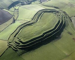
Maiden Castle Iron Age Hillfort, near Dorchester, Dorset
Maiden Castle was one of the largest hillforts in Europe. Excavations in the 1930s found that it was the site of a stand against the Roman invasion of 43 AD. This site is now in the care of English Heritage (2010).
Photograph taken October 1997 © Crown copyright. Historic England Archive ref: nmr 15852/03
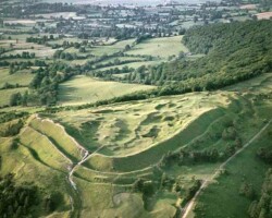
Painswick Camp, Painswick, Gloucestershire
This Iron Age hillfort (also known as Kimsbury Hillfort), is sited on the scarp of the Cotswolds overlooking the Severn valley. The interior is badly scarred by stone quarrying.
Photograph taken June 1969 © Copyright Historic England Archive ref: jeh 22024/08b
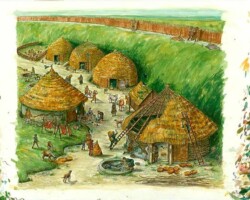
Danebury hillfort, Hampshire
Reconstruction drawing of round houses in the quarry hollow behind the rampart during the 2nd century BC. The hillfort was built c2,500 years ago and is believed to have been used for around 500 years. During the Iron Age, Britain was divided into many tribal territories, and hillforts were probably the strongholds and main settlements for these territories.
Photograph taken 1992 © Copyright Historic England Archive ref: ic030/003
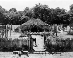
Reconstruction of an Iron Age village, Wiltshire
A reconstruction of life in the Iron Age village of Little Woodbury in Wiltshire for the BBC film Beginning of History. The hut, palisade and post structure are based on excavated evidence. (This photograph is from the Central Office of Information collection.)
Photograph taken circa 1945 © Copyright Crown copyright.NMR ref: bb68/08357
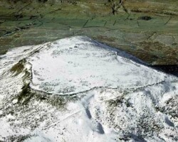
Ingleborough Hillfort, Ingleton, North Yorkshire
An aerial view of Ingleborough Hillfort under a blanket of snow. The fortified settlement was built by a British tribe called the Brigantes in the 1st century AD. The collapsed stone rampart was 3,000 feet long.
Photograph taken January 1991 © Crown copyright. Historic England Archive ref: nmr 12061/31
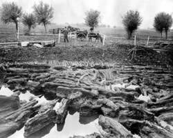
Glastonbury Lake Village, Glastonbury, Somerset
A view of excavations of the Iron Age settlement known as the Glastonbury Lake Village in Somerset. Many of the artefacts were well preserved in the marshy soil.
Photograph taken 1892-1907 © Reproduced by permission of Historic England Archive ref: bb72/02822
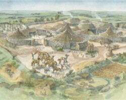
Carn Euny Ancient Village, nr Sancreed, Cornwall
This a reconstruction drawing of the remains of an Iron Age village. The first traces of settlement on the site date from the 5th century BC. For some 500 years, the village was formed of relatively simple Iron Age 'round houses'. Their walls were built of turf or wattle daubed with clay, and the roofs were probably covered with thatch or turf, supported on timber posts. These have now completely disappeared - with only the circular drainage gullies and postholes surviving, to be excavated by archaeologists in the 1960s. As part of this early settlement, a remarkable underground stone chamber with an entrance passage was built. This distinct type of monument, found only in the far west of Cornwall, is known as a 'fogou', deriving from the Cornish word 'ogo' meaning cave. This site is now in the care of English Heritage (2010).
© Judith Dobie. Historic England Archive Graphics Team ref: N070192
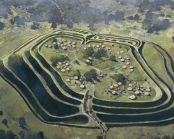
Old Oswestry Hillfort, Oswestry, Shropshire
This is a reconstruction drawing of what Old Oswestry Hillfort might have looked like. The hillfort has ramparts made of five earthen banks and ditches. There are two entrances, one on the east and one on the west. The inner two banks and ditches are the earliest and probably dating to around the sixth century BC. The visible earthworks represent several phases of construction. Each phase increased the defensive capabilities and status of the site. Excavations during the 1940s revealed that the site was in use from the Late Bronze Age through to the end of the Iron Age. The earliest occupation of the site being a Late Bronze Age settlement of round huts. A Roman phase at the site is indicated by finds of pottery and tile, but exactly where their activity was concentrated is uncertain. This site is now in the care of English Heritage.
© Ivan Lapper. Source Historic England Archive Photo Library ref: N080553
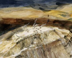
Ingleborough Hillfort, Ingleton, North Yorkshire
This is a reconstruction drawing of Ingleborough Hillfort. It was a fortified settlement that was built by a British Iron Age ,tribe called the Brigantes, in the 1st century AD. It is a stone-built rampart enclosing about twenty roundhouses. The roundhouses or huts tend to cluster in discrete groups. All are between 5.5m and 8.0m in diameter within rubble walls. The stone rampart is 3,000 feet long. At 720m, it is the highest hillfort in England.
© Judith Dobie. Historic England Archive Graphics Team ref: J970024
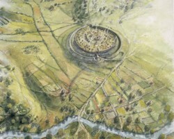
Iron Age Old Sarum Hillfort, Salisbury, Wiltshire
An aerial view recontruction drawing of Old Sarum during the Iron Age, in c200 BC. Old Sarum was an Iron Age Hillfort. Hillforts were used as administrative centres, cattlepounds and markets, but also places of safety in which whole communities could take shelter during times of threat. The site was then used by the Romans, who called it Sorviodunum. It was then used by the Anglo Saxons and Normans. The Normans built both a castle and cathedral here in the 11th century. This site is now in the care of English Heritage (2011).
Photograph taken 2003 © Peter Dunn. Source Historic England Archive Photo Library ref: J030093

Iron Age settlement, Scarborough, North Yorkshire
Reconstruction drawing of the Iron Age settlement on the headland where Scarborough Castle now stands. The drawing shows a cluster of thatched 'roundhouses', these were the typical houses of the Iron Age in Britain.
Photograph taken 2000 © Ivan Lapper. Source Historic England Archive Photo Library ref: J000082
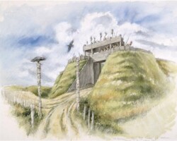
Old Sarum Iron Age Hillfort, Salisbury, Wiltshire
This is a reconstruction drawing of how the entrance and gatehouse of the Iron Age hill fort might have looked. Old Sarum was an Iron Age Hillfort. Hillforts were used as administrative centres, cattlepounds and markets, but also places of safety in which whole communities could take shelter during times of threat. The site was then used by the Romans, who called it Sorviodunum. It was then used by the Anglo Saxons and Normans. The Normans built both a castle and cathedral here in the 11th century. This site is now in the care of English Heritage (2011).
Photograph taken 2003 © Peter Dunn. Source Historic England Archive Photo Library ref: J030100

People at Old Sarum Iron Age Hillfort, Salisbury, Wiltshire
This is a reconstruction drawing showing what an Iron Age man and woman might have looked like. Old Sarum was an Iron Age Hillfort. Hillforts were used as administrative centres, cattlepounds and markets, but also places of safety in which whole communities could take shelter during times of threat. The site was then used by the Romans, who called it Sorviodunum. It was then used by the Anglo Saxons and Normans. The Normans built both a castle and cathedral here in the 11th century. This site is now in the care of English Heritage (2011).
Photograph taken 2003 © Peter Dunn. Source Historic England Archive Photo Library ref: J030114
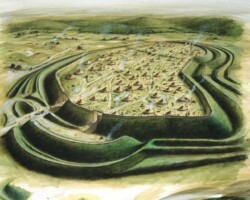
Maiden Castle, Iron Age Hillfort, near Dorchester, Dorset
This reconstruction drawing shows an aerial view of the hillfort as it might have looked during the Iron Age.
Photograph taken 1987 © Paul Birkbeck. Source Historic England Archive Photo Library ref: J870379


